www.RogerWendell.com
Roger J. Wendell
Defending 3.8 Billion Years of Organic EvolutionSM
Line


Other Peaks and Mountains that I've Climbed
that are under 12,000 feet (3,657.6 metres)

Roger J. Wendell, Linda Jagger, Amy Hastings, and Tom Jagger on top of Mount Baker (Komo Kulshan) - 06-29-2008
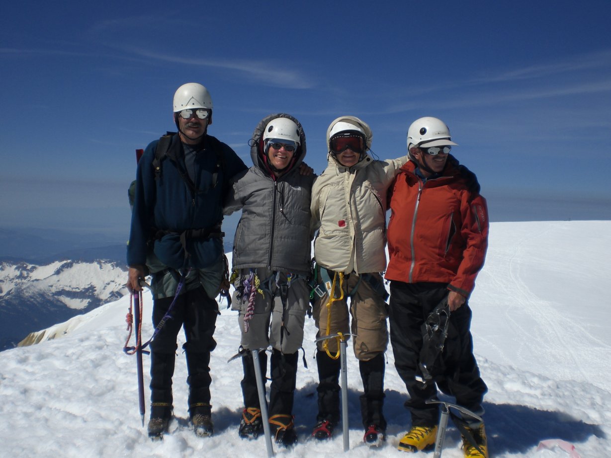
Left to Right: Me, Linda Jagger, Amy Hastings, and Tom Jagger on top of Mount Baker (Komo Kulshan) 10,778 ft - 06-29-2008
This page is going to be a long work-in-progress as I didn't think of creating until I was 67-years-old in July, 2023. My guess is that I had hiked and climbed about 500 different peaks and summits before then! (not counting my 1,200 ascents of Mount Morrison by that age and dozens of other mountains that I repeated many times as well...)
 
I started creating climbing pages with the 14ers in my early 50s. I then started adding the 12ers, 13ers, and higppoints pages in my early 60s. Prior to that I had completed countless 5ers, 6ers, 7ers, etc. that I had summited throughout my life but never recorded.
 
I climbed all of those as a boy in California, while on military duty in Hawai'i, and as a young man, adult, and then elder in Colorado. I suspect I'll never come close to piecing it all together but will try and record those I can remember or reference from other sources as time permits...  

NOTE: LIDAR (Light Detection and Ranging) was put into use many decades after I started hiking and climbing. LIDAR is a more accurate way of measuring the Earth's surface and, as such, has changed what was believed to be the elevation of many mountains and highpoints. As a result, the "prominence" (at least 300 feet above a connecting saddle) of many mountains has changed along with their elevations. A personal example, for me, is Republican Mountain - a previously "unranked" 12er near Silver Plume that I climbed in 2022 after learning that LIDAR had determined it now had 312 feet of prominence. Peak 8, near Breckenridge is another personal example of change brought on by LIDAR. When I originally climbed Peak 8 I believed it to be a 12er, only to learn later that it's actual elevation is 13,005 feet! So, in summary, many of the elevations you see on my pages may not (yet) be accurate - requiring an update someday in the future as time permits!


Arrow Pointing Right Click Here for my 14ers page...
Arrow Pointing Right Click Here for my 13ers page...
Arrow Pointing Right Click Here for my 12ers page...
Ten Essentials Click Here for the Ten Essentials - Don't leave home without 'em!
Arrow Pointing Right Click Here for my page on highpoints...
Arrow Pointing Right Click Here for my general notes Climbing and Mountaineering.


Line


My List of Peaks Below 12,000 feet/3,657.6 metres:

Roger J. Wendell on top of Mount Morrison 1,000 times - November 08, 2021
7,886 feet, 813 feet of prominence - Colorado's 3,746th highest peak
As of February, 2026 I had completed 1,458 climbs to the top of Mount Morrison (and back down again)
 
 
A note about "POTA" and "SOTA" At age 70, in 2025, I reduced the hours at my regular job down to just one day per week, becoming "mostly" retired. That gave me more time to pursue my love of Morse code, hiking and mountaineering. As such, I was able to combine these pursuits by operating QRP amateur radio in parks and on summits. So, anytime you see the acronyms "SOTA" (Summits on the Air) or "POTA" (Parks on the Air) next to a peak or place name it means I successfully "activated" that location using amateur radio.
 
 
For SOTA, as luck would have it, in late 2025 I was the first person to activate Colorado's Unnamed 10055 (W0C/SP-105), Floyd Benchmark (W0C/PR-150), and JCMD 93 Benchmark (W0C/FR-200) - I'm looking forward to many more!


11ers

  1. Badger Mountain aka Wilkerson Benchmark (11,296 ft) Park County, Colorado - November 19, 2025 [HF CW SOTA and POTA activation for a total of 52 QSOs]
  2. Chief Mountain (11,713 ft), Clear Creek County, Colorado - many times, including leading it for the CMC on 05-26-2014, and my first SOTA activation (with N5YCO) on 08-26-2025 - I completed 10 QSOs
  3. Elk Mountain (11,424 ft) Grand County, Colorado - June 30, 2024 [A black bear charged me at about 10,500 feet as I was coming down...]
  4. Estes Cone (11,009 ft) Front Range, Colorado - October 27, 2004 [with Linda Jagger, Janet Czyzewski, and Ania]
  5. Mestaa'ėhehe Mountain, formerly Squaw Mountain (11,500 ft), Front Range, Colorado - many times, evem leading it for the CMC on May 26, 2014
  6. Monarch Ridge (11,912 ft) Sawatch Range, Colorado - July 02, 2023 [with Randy Claude Neumann]
  7. Point 11014 Formerly Point 11003 (11,014 ft LIDAR) Park County, Colorado - June 19, 2024 [with Randy Claude Neumann]
  8. Telescope Peak (11,048 ft) Inyo County, California - June 07, 2011 [with Jeff Wind and his coworkers Ken, Wes, Andrea, and Caroline]
  9. Seven Utes Mountain (11,429 ft) Jackson County, Colorado - October 03, 2025 [Bill Trout's lead that included Unnamed 11188 with the NOCO CMC group and the Estes Trail Trekkers]
  10. Twin Sisters Peak, East (11,429 ft) Front Range, Colorado - July 28, 2001 (Tim Musil CMC hike including Steve Farley) [again on 04-12-2008 led by Linda and Tom Jaggeer]
  11. Windy Peak (11,970 ft) Sawatch Range, Colorado - June 11, 2005 [Dave Callais' CMC lead]


10ers

  1. Baker, Mount (10,778 ft), Komo Kulshan, Washington - June 29, 2008 (Tom and Linda Jagger, Jeff Bowman and Amy Hastings)
  2. Dakota Hill (10,930 ft), Gilpin County, Colorado - 16 February 2026 (President's Day with N5YCO and KM4CFT for a SOTA and POTA HF CW activation)
  3. Deer Mountain (10,027 ft), Rocky Mountain National Park, Colorado - June 16, 2018 (My CMC lead to fill-in for Martin Berger at his request)
  4. Fairburn Mountain (10,394 ft) Gilpin County, Colorado - February 26, 2026 (SOTA W0C/SR-053 and POTA US-4400 activation for 28 HF CW QSOs)
  5. Jefferson Hill (10,528 ft) Park County, Colorado - July 26, 2025
  6. Jones Hill (10,748 ft) Park County, Colorado - June 19, 2024
  7. Judge, Mount (10,286 ft) Clear Creek County, Colorado - September 30, 2024 (W0C/FR-047 SOTA activation with N5YCO on 02-28-2026)
  8. Ophir Mountain (10,201 ft) Summit County, Colorado - June 21, 2025
  9. Raspberry Mountain aka "Sleeping Giant" (10,610 ft), Teller County, Colorado - June 15, 2024 (Rebecca Faust's CMC lead)
  10. Santa Fe Mountain aka "Sleeping Giant" (10,550 ft), Clear Creek County, Colorado - June 24, 2025 (with Mike Cusick)
  11. Thorodin Mountain (10,545 ft), Gilpin County, Colorado - June 13, 2025 (With Garrett Pettingel, we went to both summits...)
  12. Threemile Mountain (10,017 ft), Park County, Colorado - April 26, 2025
  13. Unnamed 10094 (formerly Unnamed 10090), Park County, Colorado - HF CW SOTA/POTA activation with Corey, N5YCO (W0C/SP-101, US-4404) - November 26, 2025
  14. Unnamed 10050 (formerly Unnamed 10055), Park County, Colorado - September 14, 2025 [This mountain's first SOTA activation! I completed 28 CW QSOs on 20 meters]


9ers

  1. Bald Mountain (9,159 ft), Boulder County, Colorado - October 29, 2025 (Successful SOTA and POTA activations with Corey McDonald - N5YCO - I had 32 QSOs)
  2. Berrian Mountain (9,142 ft) Jefferson County, Colorado - September 23, 2024
  3. Blue Mountain (9,221 ft), Park County, Colorado - October 11, 2025 (Successful SOTA activation with 24 CW QSOs on 14.0585 MHz)
  4. Dakan Mountain (9,147 ft), Douglas County, Colorado - June 19, 2025 (13-year-old summit register with just a dozen entries!)
  5. Centralia (9,791 ft), Jefferson County, Colorado - August 16, 2025
  6. Devils Head (9,759 ft), Douglas County, Colorado - Summer 1973 (I earned the "squirrel card" at the top of the fire lookout!)
  7. Douglas Mountain (9,554 ft), Clear Creek County, Colorado - December 26, 2025 (42 HF QRP CW SOTA W0C/FR-054 and POTA US-11919 QSOs). Climbed it again the next day!
  8. Emerald Mountain (9,234 ft), Estes Park, Colorado - September 15, 2002 (with Steve Farley)
  9. Grouse Mountain (9,851 ft), Mueller State Park, Colorado - December 29, 2025 (POTA US-1230 activation on the summit for 38 QRP HF CW QSOs)
  10. Herman, Mount (9,068 ft), Front Range, Colorado - December 23, 2018 (Grover Cleveland's CMC lead)
  11. Legault Mountain (9,074 ft), Front Range, Colorado - July 14, 2019 (Suzy Allexan's CMC moon-rise hike)
  12. Lemmon, Mount (9,166 ft), University of Arizona's SkyCenter Observatory - June 12, 2007 (with Myrna Murphy).
  13. Little Scraggy Peak (9,199 ft), Jefferson County, Colorado - June 25, 2025 (on Wayne Howell and Rich McAdams' CMC hike).
  14. Pence, Mount (9,920 ft) Clear Creek County, Colorado - June 09, 2024 (again on 12-17-2025 with N5YCO for an HF CW SOTA activation)
  15. Pewabic Mountain (9,929 ft) Clear Creek/Gilpin County line, Colorado - December 23, 2025 (WB&Oslah;JNR SOTA activation for a total of 50 QSOs - 48 on HF CW, two on 146.52 FM)
  16. Signal Butte (9,463 ft) Teller County, Colorado - May 28, 2025
  17. Unnamed 9082 (formerly UN 9083) Park County, Colorado - November 22, 2025 (Sota/POTA W0C/SP-124/US-4404 for a total of 31 HF CW QSOs)
  18. Visitor Point (9,505 ft) Jefferson County, Colorado - September 07, 2025 (Successful SOTA activation with Ann, N5YCO, NØLNT, and me/WBØJNR - I completed 16 CW QSOs. Summit register was from May, 1994!)
  19. Windy Peak (9,151 ft) Jefferson County, Colorado - November 08, 2025
  20. Zenobia Peak and fire lookout (9,010 ft) Moffat County, Colorado - August 15, 2010


8ers

  1. Animas Mountain (8,180 ft) La Plata County, Colorado - November 03, 2010
  2. Aspen Peak (8,167 ft) Mohave County, Arizona - November 03, 2010
  3. Bennett Mountain (8,051 ft) Front Range, Colorado - December 14, 2019 (Grover Cleveland's CMC trip lead)
  4. Booger Red Hill (8,311 ft) Teller County, Colorado - JUly 01, 2025
  5. Capulin Mountain (8,182 ft) Union County, New Mexico - December 24, 2024 With Donna L. Wendell (also my SOTA activation on 09-21-2025 for 36 CW QSOs)
  6. Centennial Cone (8,661 ft), Jefferson County, Colorado - October 5, 2024
  7. Doi Inthanon (8,415 ft) Chom Thong District, Chiang Mai Province, Thailand - December 2014
  8. Doublehead Mountain (8,941 ft) Jefferson County, Colorado - December 29, 2024
  9. Elephant Butte (8,411 ft) Jefferson County, Colorado - October 26, 2024
  10. Ethel, Mount (8,481 ft) Larimer County, Colorado - October 26, 2024 (with owner's permission for Anita Wright's group)
  11. Evergreen Mountain (8,557 ft) Jefferson County, Colorado - October 26, 2024
  12. Green Mountain (8,145 ft) Boulder County, Colorado - October 26, 2024
  13. Floyd Benchmark (8,238 ft) Clear Creek and Gilpin County Line, Colorado - October 18, 2025 [This mountain's first SOTA activation! I completed 23 QSOs]
  14. Genesee Mountain (8,272) Front Range, Colorado - many times for the Colorado QRP Club's annual picnic, POTA and SOTA activations - I'm in white on the right. [I conducted my own SOTA activation with N5YCO on 09-01-2025 where I completed 14 QSOs]
  15. Green Mountain (8,145 ft) Boulder, Colorado - and a half-dozen times over the years...
  16. Guadalupe Peak aka El Capitan Benchmark (8,750 ft) Texas higpoint December 10, 2011
  17. Muscoco, Mount (8,023 ft) El Paso County, Colorado - in conjunction with Mount Cutler
  18. Oil Spring Mountain (8,580 ft) Rio Blanco County, Colorado - September 29, 2018 (Steve Bonowski's CMC Conservation trip lead with Kaila Hood, an aid to Congresswoman Diana DeGett)
  19. Sheep Mountain (8,450 ft) Larimer County, Colorado - May 31, 2003 (Sheryl Randall's CMC trip lead)
  20. Sierro del Ojito (8,182 ft) Conejo County, Colorado - December 08, 2024
  21. South Boulder Peak (8,550 ft) Front Range, Colorado - April 29, 2000 (CMC lead by Rico Argentati) - and a half-dozen other times over the years
  22. Sugarloaf Mountain (8,924 ft) Boulder County, Colorado - October 29, 2025
  23. Triangle Mountain (8,406 ft) Larimer County, Colorado - October 30, 2025 SOTA and POTA activation on HF CW with Randy Claude Neumann - 25 QSOs
  24. Tappan Mountain (8,960 ft) Park County, Colorado - June 06, 2025
  25. Unnamed 8607 (Formerly UN 8595) Clear Creek County, Colorado - October 25, 2025 (with Corey McDonald, N5YCO) - We did a SOTA activation on 7, 10, 14, and 21 MHz - I had 26 QSOs


7ers

  1. Bald Mountain (7,892 ft) Douglas County, Colorado
  2. Baldy Peak (7,882 ft) aka "Humprey's Dome" Jefferson County, Colorado - 12 April 2025
  3. Black Elk Peak, formerly Harney Peak (7,242 ft) South Dakota highpoint - May 23, 2009
  4. Dawson Butte (7,486 ft), Douglas County, Colorado - June 19, 2025
  5. Falcon, Mount (7,856 ft) Front Range, Colorado - 45 times as of November, 2023
  6. Fremont Peak (7,233 ft) Fremont County, Colorado - 21 December, 2024 (Winter Solstice hike lead by CMCer Jacqueline Hooper)
  7. (7,856 ft) Larimer County, Colorado - 01 Decmeber, 2024 [Wayne Howell's CMC lead]
  8. Horsetooth Mountain (7,258 ft) Larimer County, Colorado - 12 February 2026 [I did all three "bumps" plus an HF CW SOTA activation for a total of 35 QSOs]
  9. JCMD 93 Benchmark (7,946 ft) Jefferson County, Colorado - 11 December 2025 [This mountain's first SOTA activation! I completed 30 QSOs, mostly on HF CW]
  10. Morrison, Mount (7,886 ft) Front Range, Colorado - 1,450 times as of December, 2025
  11. Saddleback Mountain (7,952 ft) Conejos County, Colorado - 08 Decmeber, 2024
  12. Sheep Mountain (7,950 ft) Jefferson County, Colorado - 16 Decmeber, 2025


6ers

  1. Dora, Mount (6,290 ft) Uniton County, New Mexico - June 09, 2025
  2. Garfield, Mount (6,777 ft) Mesa County, Colorado - April 27, 2011
  3. Glennon, Mount (6,483 ft) Jefferson County, Colorado - June 09, 2024
  4. Green Mountain (6,851 ft) Jefferson County, Colorado - 210 times as of November 23, 2025 (My SOTA activation on 09-13-2025 for 9 FM QSOs)
  5. Kuwohi aka Clingmans Dome (6,645) Tennessee highpoint - October 02, 2012
  6. Mitchell, Mount (6,684 ft) North Carolina highpoint - October 01, 2012
  7. North Table Mountain (6,591 ft) Jefferson County, Colorado - August 23, 2025
  8. South Table Mountain (6,336 ft) Golden, Colorado - December 20, 2023 (Wayne Howell's CMC lead)
  9. Unnamed 6721 (6,721 ft) San Juan County, Utah - October 01, 2025
  10. Wildcat Mountain (6,662 ft) Douglas County, Colorado - November 09, 2025


5ers

  1. Devils Tower (5,113 ft) Crook County, Wyoming - July 16, 1994 (Dan Howell and I swung the lead via the Durrance route)
  2. Goat Hill (5,604 ft) Larimer County, Colorado - May 23, 2025
  3. Hogback Mountain (5,075 ft) Banner County, Nebraska - January 02, 2026 (with John Collard)
  4. Reservoir Benchmark "Reservoir Ridge" (5,740 ft) Larimer County, Colorado - May 23, 2025
  5. Wilson, Mount (5,710 ft) San Gabriel Mountains, California - over a dozen times up from Chantry Flat until mid 1972


4ers

  1. Bead Mountain (4,626 ft) Scotts Bluff County, Nebraska - January 02, 2026 (With John Collard)
  2. Black Mountain (4,139 ft) Kentucky's highpoint - October 17, 2015
  3. Brasstown Bald (4,784 ft) Georgia's highpoint - September 30, 2012
  4. Cimarron County Prominence Point (4,836 ft) Cimarron County, Oklahoma - May 12, 2025
  5. San Jose Ranch Mesa (4,859 ft) Bent County, Colorado - May 18, 2025
  6. Scotts Bluff (4,650 ft) Scotts Bluff County, Nebraska (Scotts Bluff National Monument) - February 11, 2026
  7. Two Buttes (4,710 ft) Prowers County, Colorado - December 17, 2023


3ers

  1. Sassafras Mountain (3,552 ft) South Carolina highpoint - October 01, 2012
  2. White Butte (3,508 ft) North Dakota's highpoint - May 24, 2009 [with Tom and Linda Jagger, Dawn Brown, and Dorothea Frohner]


2ers

  1. Cheaha Mountain (2,409 ft) Alabama highpoint 09-30-2012
  2. Hieizan, Mount (2,282 ft) on the border between the Kyoto and Shiga Prefectures, Japan - July 12, 2017 [again on 11-08-2024 with Roger A. Wendell]
  3. Magazine Mountain on Signal Hill (2,753 ft) Arkansas highpoint 10-05-2012
  4. Sajikigatake, Mount (2,939 ft) on the border between the Kyoto Prefectures, Japan - July 11, 2017 (I hiked much of it barefoot and had to remove four leaches from my feet after crossing the stream...)


1ers

  1. Campbell Hill (1,548 ft), Ohio highpoint - October 17, 2015
  2. Hoosier Hill (1,257 ft), Indiana highpoint - October 18, 2015
  3. Daimonji-yama, Mount (1,492 ft), Kyoto, Japan - July 10, 2017
  4. Tempe Butte aka O'odham: 'Oidbaḍ Do'ag (1,499 ft), Maricopa County, Arizona - March 01, 2014 (with Mark Silas, Dave Bower, and Chuck Cummings while we were on a layover in Phoenix on our way to my CMC lead up Orizaba)
  5. Tapochau, Mount (1,555 ft), Saipan, Norther Mariana Islands - June 2015 (with John Mitchler, Roger and Clint Kaul)
  6. Tempe Butte (1,499 ft), Heydan Butte Park, Arizona - December 2014
  7. Tom Sauk Mountain (1,772 ft) Missouri highpoint 10-10-2015
  8. Victoria Peak (1,811 ft), Hong Kong - December 2014


0ers

  1. Alto de Coloane (566 feet) Island of Coloane, Macau, China - December 2014
  2. Inari, Mount (764 ft) Kyoto Prefecture, Japan - November 05, 2024 [with Donna L. Wendell - there's a temple on the very top!]
  3. Kastiyu (614 ft), Tinian Island, CNMI - June 2015


Roger J. Wendell on Bergen Peak now 9714 feet - May 22, 2022
Me on top of Bergen Peak (2,960 metres) after a spring snowstorm
Phil Kummer, Randy Claude Neumann, and Roger J. Wendell on top of Storm Peak - May 17, 2014
Storm Peak (9,201 ft), Front Range, Colorado - Phil, Randy, and Roger
Roger J. Wendell on top of MountBaker (Komo Kulshan) - Jun 29, 2008
Me on top of Mount Baker (Komo Kulshan) 10,778 feet / 3,285 metres


Unranked (less than 300 foot rise)

  1. Bear Peak (8,463 ft) Boulder, Colorado October 22, 1998 (again on 11-24-2002 with Steve Bonowski's group, 11-20-2004 with Tom and Linda Jagger and then a half dozen other times after that...)
  2. Bergen Peak (9,714 ft) Front Range, Colorado - 11-09-2002 on Steve Bonowski's CMC conditioner with Janet Farrar and 7 others (Dozens of other times as of 2025 including many winter ascents)
  3. Black Mesa (4,976 ft) Oklahoma highpoint 05-14-2006
  4. Britton Hill (345 ft) Florida highpoint 09-29-2012
  5. Carbon, Mount (5,787 ft), Bear Creek Lake Park, Colorado - numerous times
  6. Castle Rock (8,051 ft), Boulder County, Colorado - May 13, 1993 (with Dan Howell)
  7. Cob Rock (6,790 ft), Boulder County, Colorado - June 11, 1993 (with Dan Howell)
  8. Combat Rock (7,241 ft), Larimer County, Colorado - October 02, 1994 (with Kevin Friesen)
  9. Cutler, Mount (7,232 ft), El Paso County, Colorado - in conjunction with Mount Muscoco
  10. Dinosaur Ridge, AKA Dakota Ridge (6,652 ft), Jefferson County, Colorado (253 feet of prominence) 39.69471°N, 105.20014°W - 12-15-2024
  11. Dome, The (5,874 ft), Boulder County, Colorado - January 28, 1993 (with Kevin Friesen and then again on November 10, 1996 with Jim Leffingwell)
  12. Driskill Mountain (535 ft) Louisiana highpoint 10-05-2012
  13. Elephant Buttress, Fourth (5,715 ft) Boulder County, Colorado 10-01-1995 (with Jeff Wind)
  14. Flatiron, First (7,300 ft) Boulder County, Colorado - many times (once without clothing...)
  15. Flatiron, Second (7,140 ft) Boulder County, Colorado - many times
  16. Flatiron, Third (7,220 ft) Boulder County, Colorado - many times ("free soloed" it a few times alone, with Kevin Freezen, and with Jeff Wind in the 1990s)
  17. Flatiron, Fourth (7,630 ft) Boulder County, Colorado - a couple of tiems in the 80s and 90s (last time was with Jack Dennis's CMC group and co-leader Bob Montok on 11-09-1996)
  18. Flatiron, Fifth (7,500 ft) Boulder County, Colorado - a couple of times in the 80s and 90s (last time was with Rene Kupfer's CMC group on 09-15-2001)
  19. Galbraith, Mount (7,315 ft) Jefferson County, Colorado - October 15, 2025
  20. Goat Mountain (7,795 ft) Front Range, Colorado - November 02, 2003 (with Doug Cook and Greg Olson)
  21. Hill Billy Rock (7,020 ft) Boulder County, Colorado - May 10, 1998 (CMC BMS director Ginni Greer's lead)
  22. Horsetooth Rock (7,258 ft) Larimer County, Colorado - 12 February 2026 [I did all three "bumps" plus an HF CW SOTA activation for a total of 35 QSOs]
  23. Independence Peak (8,250 ft) Jefferson County, Colorado - September 27, 2024 (Wayne Howell's CMC lead)
  24. Jackson Creek Dome (8,303 ft) Douglas County, Colorado - September 17, 2000 (Steve Holonitch's CMC lead)
  25. Kuili (342 ft) Big Island, Hawai'i - January 24, 2026
  26. Leavenworth Mountain (11,100 ft) - Front Range, Colorado - October 06, 2018 (Norm Arlt's CMC lead)
  27. Liberty Cap (5,910 ft) Mesa County, Colorado - November 11, 2009
  28. Matron, The (7,220 ft) Boulder County, Colorado - September 22, 2022 (with John Schaphorst)
  29. Middle Tooth (7,257 ft) Larimer County, Colorado - 12 February 2026 [I did all three "bumps" plus an HF CW SOTA activation for a total of 35 QSOs]
  30. Miller Rock (8,705 ft) Boulder County, Colorado - August 23, 1998 (with Jeff Wind) (Again on 09-26-1998 for my Sierra Club retreat lead as the Rocky Mountain Chapter's Outings Chair) LOJ
  31. North Sheep Mountain (8,315 ft), Roosevelt National Forest, Colorado - May 26, 2019 (Grover Celevland's CMC lead)
  32. Panorama Point (5,429 ft) Nebraska highpoint - December 16, 2012
  33. Plymouth Mountain (7,283 ft) Front Range, Colorado - December 05, 2011 (Steve Bonowski's CMC lead)
  34. Prospect Peak (11,860 ft) Eagle County, Colorado - July 19, 2025
  35. Pu'uhuluhulu (6,758 ft) Big Island, Hawai'i - January 28, 2026
  36. Puu Oo (562 ft) Big Island, Hawai'i - January 23, 2026
  37. Quarry Peak (6,535 ft) North Table Mountain, Jefferson County, Colorado - August 23, 2025
  38. Reynolds Hill (8,273 ft) Albany County, Wyoming - September 11, 1994 (with Kevin Friesen)
  39. Seal Rock (7,260 ft) Boulder County, Colorado - October 14, 2002 (with John Schaphorst )
  40. South Peak (6,509 ft) North Table Mountain, Jefferson County, Colorado - August 23, 2025
  41. Split Rock (8,541 ft) Chaffee County, Colorado - July 31, 1994 (with Chris DePuy)
  42. Spruce Mountain (7,617 ft) Douglas County, Colorado - December 26, 2018 (CMC lead by Gina Morelli and Mike O'Conner with Dean Waits identifying Culturally Modified Trees)
  43. Storm Peak (9,201 ft) Front Range, Colorado - at least three times, the last was on Steve Bonowski's CMC Conservation hike on September 7, 2019
  44. Sunflower, Mount (4,041) Kansas state highpoint - March 13, 2014
  45. Tahana Mountain (11,958 ft) Park County, Colorad - March 13, 2014 (while on Stan Moore's CMC lead)
  46. Twin Owls, Thee (8,789 ft) Larimer County, Colorado (with Kevin Friesen)
  47. Twin Sisters Easte (11,428 ft) Larimer County, Colorado (John Schaphorst was the replacement leader for this trip - we did not do the west peak)
  48. Victoria, Mount (11,789 ft) Summit County, Colorado with Terry Chontos' CMC group while climbing Peak One on 06-28-2005
  49. Unnamed 11188 Locals have labeled it, "Aces and Eights" (11,188 ft) Jackson County, Colorado 10-03-25 [Bill Trout's lead that included Seven Utes Mountain with the NOCO CMC group and the Estes Trail Trekkers]
  50. Wildcat Mountain (5,039 ft) Banner County, Nebraska 01-02-2026 (with John Collar enroute Hogback Mountain)
  51. Woodall Mountain (807 ft) Mississippi highpoint (formerly Yow Hill) 10-04-2012


Line


Some Trailheads:

Chicago Lakes Trailhead 52 Roger J. Wendell by Steve Farley - 10-16-2011
Mount Evans Wilderness, Colorado


Ute Creek Trailhead, Lost Creek Wildnerness - 11-11-2011
Ute Creek Trailhead, Lost Creek Wilderness
Arizona Snowbowl (for Humphreys Peak) N 35° 19.876' W 111° 42.697' 9,278 feet 2,828 metres
Bartlett Trailhead, Greenhorn Wilderness, Colorado N 37° 52.703' W 104° 57.491' 8,000 feet 2,438 metres
Berthoud Pass trailhead - US Highway 40
Berthoud Pass summit
N 39° 47.902' W 105° 46.563' 11,307 feet 3,446 metres
Borah Peak Trailhead (at the little cattle protected entrance through the wooden fence) N 44° 07.954' W 113° 50.042' 7,400 feet 2,255 metres
Continental Divide Trail at Henderson Mine Road, Colorado N 39° 44.260' W 105° 51.219' 10,496 feet 3,199 metres
Thomas Lakes Trail 1958, Elks Range, Colorado (for Mount Sopris) N 39° 18.236' W 107° 07.478' 8,540 feet 2,603 metres
Ute Creek trailhead, Lost Creek Wilderness, Colorado N 39° 11.885' W 105° 33.212' 8,750 feet 2,667 metres


Line


Prominence, a Definition:

In topography, "prominence" is the height of a mountain or hill's summit by the vertical distance between it and the lowest contour line encircling it and no higher summit - Prominence is a measure of the independence of a summit. Only summits with a sufficient degree of prominence are regarded as independent mountains. For example, the world's second-highest mountain is K2 (height 8,611 metres, prominence 4,017 metres). While Mount Everest's South Summit (height 8,749 metres, prominence about 10 metres) is taller than K2, it is not considered an independent mountain because it is a subsummit of the main summit (which has a height and prominence of 8,848 metres).


Line


Yosemite Decimal System

The Yosemite Decimal System (YDS) is a three-part system used for rating the difficulty of hikes and climbs. YDS is primarily used by mountaineers in the United States and Canada. However, there are many different rating systems used around the world. Examples include the British trad grade, the French sport grade, and the International Climbing and Mountaineering Federation's (UIAA) alpine grade. As for the YDS, it was first devised by members of the Sierra Club in Southern California in the 1950s. YDS was a refinement of earlier systems, particularly those developed in Yosemite Valley.
Class 1: Hiking on a trail.
 
Class 2: Simple scrambling, with the possibility of occasional use of the hands. Little potential danger is encountered.
 
Class 3: Scrambling with increased exposure. Handholds are necessary. A rope could be carried. Falls could easily be fatal.
 
Class 4: Simple climbing, possibly with exposure. A rope is often used. Falls may well be fatal.
 
Class 5: Is considered technical roped free climbing; belaying is used for safety. Un-roped falls can result in severe injury or death. Class 5 has a range of sub-classes, ranging from 5.0 to 5.15d, to define progressively more difficult free moves.
 
Classification of climbs can vary quite a bit depending on location and history. Indoor gym ratings tend to be inflated compared to outdoor ratings. Ratings tend to be lower in outdoor areas where climbing routes were developed in earlier years. Guidebooks have often raised the ratings on older climbs to make them more comparable to newer ratings. The YDS grade system also involves an optional Roman numeral grade that indicates the length and seriousness of the route. The grades are:
Grade Duration
I One to two hours of climbing
II Less than half a day
III Half a day climb
IV Full day climb
V A climb lasting 2–3 days
VI A climb lasting 4–6 days
VII A climb lasting a week or longer


Line


Summit Registers

Douglas Mountain Summit Register Retrieved on 12-16-2025
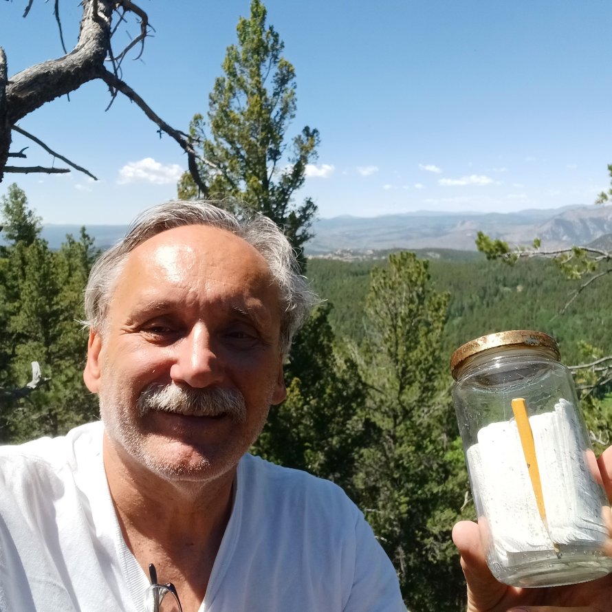
Douglas Mountain, Clear Creek County, Colorado
For me, summit registers (held in specifically designed summit cannisters or, sometimes, in mayonnaise jars or other odd containers…) are always a fun find on the top of any peak!
 
However, a few years after the millennium things got a little out-of-hand and land managers (parks, BLM, forests, etc.) started discouraging their use. This was because geocaching was growing in popularity and mountain-top memorials were becoming even more popular. As such, peaks were becoming cluttered with boxes, bottles, brass plates, skis, and all sort of other junk.
 
In 2013 I started regular work with the Colorado Mountain Club (CMC)and had the archiving of summit registers (and the distribution of summit cannisters) as a collateral duty.
 
Historically, the CMC would handover any turned-in summit registers to Katie, the longtime archivist at the American Mountaineering Center in downtown Golden. Once hired by the CMC, I continued this practice but also honored the wishes of land managers by not making summit cannisters and registers available anymore.
 
However, “freelancers” continued creating all sorts of cannisters, for hundreds of peaks, with the completed registers ending up at the CMC office as in the past. So, to this day, although the CMC does not encourage (or supply!) summit registers they still take-in full registers for archiving.
 
One complication, at the time of this writing in 2026, is that the American Mountaineering Center had been sold a year earlier so, eventually, a new location for the archives (along with the mountaineering museum and library) will have to be established.
 
I have no idea when/where a new location for the archives will be established but it’s clear that there will continue being a lot of interest in the issue. While I was employed by the CMC it was quite common for people to request access to the archives for a variety of reasons – but the most common was probably to search old summit records for the name and date of a long-lost relative who had reached a particular peak in the past.
 
Whatever the reason, I hope that these old records are kept in perpetuity as they’re a very interesting part of our mountaineering history!
 
- Roger J. Wendell, January 2026


Line


Links:

  1. 10th Mountain Division
  2. 12ers
  3. 13ers
  4. 14ers
  5. 14ers.com
  6. Aconcagua
  7. Africa (Eastern) - Kenya, Tanzania, and my Kilimanjaro climb
  8. Africa (Southern) - Our trip through Botswana, South Africa, Zambia, Zimbabwe
  9. AIARE - The American Institute for Avalanche Research and Education
  10. Alpine Resuce Team - Evergreen, Colorado
  11. Amazonia and Ecuador
  12. American Alpine Club
  13. American Avalanche Association
  14. Antarctica
  15. Argentina and Brazil
  16. Australia Main Page
  17. Australia Two Page
  18. Barefoot
  19. Bolivia
  20. Camping
  21. Champ Camp
  22. Climbing
  23. Climbing Photos
  24. CMC - Colorado Mountain Club
  25. Cross Country Ski Areas Association
  26. COHP - County High Points
  27. Colorado
  28. Colorado Avalanche Information Center
  29. Colorado Fourteener Iniative - A Partnership for Preservation
  30. Everest News
  31. Gear - Stuff for the Backcountry...
  32. High Altitude Medicine Guide
  1. Highpointers Club
  2. Highpoints
  3. Hiking
  4. Japan
  5. Leave No Trace - Center for Outdoor Ethics
  6. Lightning Safety
  7. LOJ - Lists of John
  8. Margy's Hut
  9. Mazamas - Oregon
  10. Mountaineers - Seattle
  11. Mountain Project
  12. New Zealand
  13. ORIC - Outdoor Recreation Information Center - Colorado
  14. Peakbagger.com
  15. Peakery
  16. Pikes Peak
  17. Russia
  18. Silk Road
  19. Skiing - in the backcountry!
  20. Skins, Wax and Waxless Skis
  21. Snow Caves
  22. Snow Day
  23. Summitpost.org
  24. Survival in the backcountry
  25. Ten Essentials - Don't leave home without 'em!
  26. Tibet
  27. Travel and Travel Two - my travel pages!
  28. UIAA - International Mountaineering and Climbing Federation
  29. United Kingdom - England
  30. United Kingdom - Wales and Scotland
  31. Walking softly in the backcountry
  32. Waypoints


Warning! Climbing, mountaineering, and backcountry skiing are dangerous and can seriously injure or kill you. By further exploring this website you acknowledge that the information presented here may be out of date or incorrect, and you agree not to hold the author responsible for any damages, injuries, or death arising from any use of this resource. Please thoroughly investigate any mountain before attempting to climb it, and do not substitute this website for experience, training, and recognizing your limitations!


Line


Back to Roger J. Wendell's Home Page...

Web Counter Logo
Hit Counter by Digits


Abbey | About | Blog | Contacting Me | Copyright | Disclaimer | Donate | Guest Book | Home | Links | Site Index | Solutions | Terms, Conditions and Fair Use | What's Changed or New?
Copyright © 1955 -